How the Ancient Egyptian Captain Rata and his Navigator Maui Discovered America in 232 BC
Who discovered America first is an important topic. Obviously the so-called Indians came by a land bridge from Asia some 16,000 years ago, but what about the earliest voyages? Eric the Red is mentioned a a Viking explorer who landed first at Greenland, and then there is Columbus whose voyage in 1492 is usually cited as the first. But what about the Muslim Admiral of the Chinese fleet, Zheng He, who sailed from China to the Western part of North America in 1421, fully 71 years ahead of Columbus. Then, astoundingly, there is the incredible voyage of the ancient Egyptians, Captain Rata and his Navigator Maui, who reached South America in 232 BC! That's 16 centuries before Zheng He and Columbus. How did they do this remarkable feat? Here is some recently arrived at understandings of the technology they used to find their way there and back home to Egypt.
Around the year 232 B.C., Captain Rata and Navigator Maui set out with a flotilla of ships from Egypt in an attempt to circumnavigate the Earth.1 On the night of August 6-7, 2001, between the hours of 11 PM and 3 AM, this writer, and fellow amateur astronomer Bert Cooper, proved in principle that Captain Rata and Navigator Maui could have known and charted their location, by longitude, most of the time during that voyage.
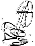
The Maui expedition was under the guidance of Eratosthenes, the great scientist who was also the chief librarian of the library at Alexandria. Could this voyage have demonstrated Eratosthenes' theorem that the world was round, and measured approximately 24,500 miles in circumference? One of the navigational instruments which Maui had with him was a strange looking "calculator" that he called a tanawa; such an instrument was known, in 1492, as a torquetum.
Intrigued by a photograph of the cave drawing of that tanawa in Irian Jaya, western New Guinea, I speculated that Maui must have been looking at the ecliptic to measure "lunar distance," in order to find his longitude. Maui's tanawa was of such importance, that he drew it on the cave wall with the inscription, deciphered in the 1970s by epigrapher Barry Fell: "The Earth is tilted. Therefore, the signs of half of the ecliptic watch over the south, the other (half) rise in the ascendant. This is the calculator of Maui."
Eratosthenes had just measured the circumference of the Earth, and the circumference of a sphere is the same in all directions. We know that Maui was thinking about this, because his cave drawings also include a proof of Eratosthenes' experiment to measure the Earth's circumference.
To test the hypotheses, we built a wooden torquetum and used a simplified version of it to measure the change in angular distance between the Moon and the star Altair, in the constellation Aquila (the Eagle). This success proves official dogma wrong, and proves that, in principle, Navigator Maui, during his voyage could have used tables brought from Alexandria, drawn up by Eratosthenes or his collaborators, compared those lunar distances with the distances that he measured, and come up with a good estimate of his longitude.
It is important to note that we are not claiming here that we know everything about the torquetum. We simplified our device for the proof-of-principle experiment, but we will carry out and report on more experiments, using the full instrument.
The torquetum's value, as an analogue calculator, must have been immense, because, once a planet or the Moon are not on the meridian, all "straight lines" become curves—so that calculations are difficult, even with a modern calculator. However, the 23.5-degree plane on the torquetum allows one to directly read the longitude and latitude of a planet or the Moon, relative to the ecliptic, without calculation. These data would be invaluable for predicting eclipses and occultations of various stars or planets by the Moon.
The Inspiration for the Experiment
This was intriguing! What was this "tanawa" for? Why the 23.5-degree plane, characteristic of the torquetum? It could only mean that Maui was looking at the ecliptic, the Moon, and the planets, the "wandering stars."
Of the two torquetums surviving in the world, one belonged to Nicholas of Cusa, and the other to Regiomontanus, both of whom were involved in calendar reform, including setting the date of Easter, which, along with some other religious festivals, is dated by the interaction of the lunar and solar calendars.
But what could Maui have been doing? Trying to determine longitude? The very thought was heretical. To take things out of the realm of speculation, the only solution was to build a torquetum, and see if longitude could be determined by using sightings of the Moon, with simple backyard equipment; if this succeeded, then Navigator Maui could have also succeeded.
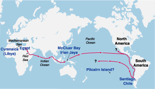
PROBABLE ROUTE OF THE EGYPTIAN VOYAGE IN 232 B.C.
Deciphered rock and cave inscriptions from the Pacific islands, western New Guinea, and Santiago, Chile, tell of an Egyptian flotilla that set sail around 232 B.C., during the reign of Ptolemy III, on a mission to circumnavigate the globe. The six ships sailed under the direction of Captain Rata and Navigator Maui, a friend of the astronomer Eratosthenes (ca. 275-194 B.C.), who headed the famous library at Alexandria. Maui's inscriptions, as deciphered in the 1970s by epigrapher Barry Fell, indicated that this was a proof-of-principle voyage, to demonstrate Eratosthenes' theorem that the world was round, and approximately 24,500 miles in circumference.